28 March 2011 – Turtlehead Island, Torres Strait, QLD (backlogged entry)

Well, three days have already gone by since I arrived here at the Torres Pearl Farm, and I’ve been having a blast! I had spent Friday afternoon in Cairns (pronounced “Cans”), walking and window shopping (there’s not much else to do, it seems). My 20-hour impression of Cairns was that of a city filled with tour offices, expensive seaside cafes, and shopping, shopping, shopping (high-end as well as kitsch). The city is basically plastered with neon brochures advertising cruises, sailing charters, and SCUBA dive opportunities, and I wasn’t in town 20 minutes before my bag was filled with pamphlets recommended by tour offices. Ahg! Stay away from my wallet!! Luckily my dose of Cairns was small—I spent one night on the outskirts of town then caught my flight out the next morning (Saturday the 26th). I’ll return to Cairns in 2 weeks, so I have some time to decide whether or not to do much diving from that city, or just move on to other “Gateways” to the GBR.


Left: Departing Cairns to head north to Cape York Peninsula, of COURSE the flight had to take a long arch over the GBR as part of the not-so-straight-shot route to the Torres Strait! Right: First glimpse of the GBR, inner reefs!
~~ ~~ ~~
I’m not sure when I had decided that Torres Strait was on my Australia Must-See list. I think there’s a particular fascination up here (for me) because the Far-Far North Queensland is one of the last great frontiers in Australia: a truly wild region where there are certainly way more crocodiles that people and being so tropical and close to Papua New Guinea it has a totally different vibe and culture than the rest of Australia. It’s hardly mentioned in any tourist source: some books state outright that there’s nothin’ to see up here, others spin the unsealed “highway” as a challenge to hard-core 4WD trailblazers, but without any particular destination. I had read that the top of the cape had always been a sort of No-Man’s-Land between the Pacific Islanders and the Aboriginal mainlanders because the warlike Islanders used to hunt dugongs, turtles, and peaceful Aboriginal people for dinner (cannibals). The land up here is almost exclusively Mangrove forest, with meandering rivers and creeks looping between the Coral Sea to the East and the Gulf of Carpenteria to the West, and is ruled by crocs, dugongs, river dolphins, gigantic barramundi fishes, and the less brawny shorebirds.


Jelly-bean and Cuttlebone shaped coral/sand cays in the northern part of the GBR. Left: Oz's #1 drift dive spot, Bligh's Boat Entrance, at top of pic. Right: western cays part of the Great Detached Reef (Tijou Reefs?)
Whatever was the initial draw, flying up to Bamaga on Saturday—with the purpose of living and working on a small pearl farm—was perhaps the most giddy I have felt since arriving in Australia. There’s only one flight to Bamaga every day, from Cairns. Want to get there from Sydney? Too bad. From Darwin? Not a chance. Regardless, I officially recommend to anybody traveling in Oz to just take any flight along the Northern Queensland coast. For the same price as a 2-hour Great Barrier Reef flight, I paid for a round trip ticket up to Horn Island and back. While we didn’t fly in circles around the reef, we were in such a small plane that we cruised right over the ribbon reefs, and coral islands that make up the northern half of the GBR for 2 hours, WITH lunch! ;)


Left: flying over the Jackey Jackey River to land in Bamaga. At the top of the pic is the mouth to the Coral Sea, with the last creek on the right leading south to the Escape River. Right: with the boat full of fuel and supplies, we arrive at Turtlehead Island, in the mouth of the Escape River, my home for the next 2 weeks! Below: colorfully painted Torres Pearl Farm campus, my house is the little blue one. :)
 When I landed in Bamaga, Rusty picked me up and we headed down the stream between mud banks and encroaching mangroves. My arrival had coincided with Rusty’s bi-weekly trip into “town” for supplies, so we were loaded down with jugs of fuel, food, and goodies, just barely buoyant enough to squeeze through the nearly empty low-tide creeks. Not 5 minutes down the stream from the boat ramp, Rusty turns and says very seriously “This is an ‘All-Hands-In-The-Boat’ kind of stream”. It wasn’t more than a couple minutes later that we spotted the first crocodile (about a 9-footer) slide into the river just a couple meters in front of the boat! The ironic part of it was that we had been cruising for another 20 minutes before Rusty announced that NOW we were in the WILDERNESS, and we still had a ways to go!! Where exactly had we been previously?! It all looked pretty wild to me. Bamaga is the only accessible town up here, with just the basic necessities—airport, post office, mechanic, grocery. No bank nor pharmacy: just the necessities, for sure! But there are a few small homes and fishing docks hidden among the mangroves for a few miles before the waterways are completely untouched.

Above: Turtlehead Island's Front Beach, on the Coral Sea. Bronwyn and I beachcombed for cool flotsam and seashells (like this coral-encrusted runner) while Rusty went fishing for dinner. Below: The dogs love Front Beach because it is the only wide open expanse that's croc-free at low tide.
 It poured down buckets all night, then all yesterday morning, then most of the afternoon. Relentless rain that streamed under the buildings and overflowed the water tanks, and turned the water the color of strong coffee. The clouds never parted, but the rain let up for a few hours, so we loaded the dogs into the boat and coasted around the island to the Coral Sea. Rusty let us ladies out with the dogs while he went off to fish for dinner. I know fishing sounds more exciting than walking on a flooded, soggy beach, but let me tell you, this one was a beachcomber’s dream. The storms had brought in not only heaps of nautilus shells, but also tons of ocean plastics—everything from salvageable stuff like buoys and rope to bottles and baby toys to the icky small fragments and nertles. One gets mixed feelings about all this human debris on the beaches, because while it’s testament to how irresponsible people are about caring for the oceans, it is also lots of fun to imagine all the sorts lives these items had before ending up on this particular beach. For example, what has this lone shoe been up to that it is now covered in coral heads? Or, isn’t anybody missing this important-looking safety helmet or line of barrel buoy? And how many thousands of people are out there walking around with one flip-flop?! Tomorrow most of this beach junk will have moved on and will be replaced by a whole new set of stuff.
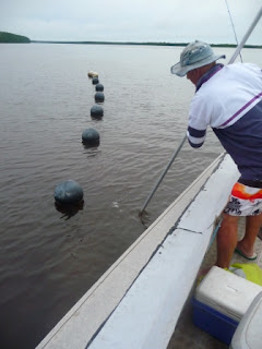

Above: rusty fishes down to pull up one of the pearl shell, Pinctata maxima, baskets growing the rare pink pearls. Below: matrix of buoys and pearl shell baskets. It looks like a lot of floats, but the whole farm takes up only a tiny fraction of the waterways. Heaps of space for dolphins and the rare boat traffic.
 This morning I helped Bronwyn clean a bunch of young Penguin Oysters, which recruit to the Pearl Oyster (Pinctata maxima) baskets and are raised for growing small half-pearls. Then we all went out to check on some of the Pink Pearl oyster baskets up the river. Years and years before Rusty and Bron took over the farm, the Escape river had been famously known as one of the few sources of pink pearls—traditional pearls are white, and there’s also oysters that produce black, gold, silver, and gray pearls. Perfect pink pearls are particularly rare and nobody seems to know (at least, in the industry) what exactly makes them pink. I guess that’s
why they wanted me up here...yay, science!


Penguin shells, for growing Mabe Pearls
This evening we sat on the dock for sunset and watched a lone snub-nosed river dolphin feed not 10 meters from our feet, while Rusty tried some fishing, aided by CB, who gave a valiant effort at NOT barking at the dolphin and the fish (he’s trained to bark at boats and crocodiles). And now it’s lights out for me and the rest of the island—the power (diesel generator) is switched on only 6-8 hours per day here—so I guess this is good night!

Above: Snub-nosed Dolphin cruising for fish near the pearl farm buoys and dock. Below: CB stands as croc-sentry while Rusty fishes and Bron and I watch the dolphin


Seriously...What day is it? And does it matter, when the sunset is really the important part of the day?! :)
We motored across waterways large and small, none of which had markers or much of a landmarks on the banks (making long-distance navigation an impressive skill!) and reached Turtlehead Island about 1.5 hrs later, without seeing a single other vessel, but plenty of crocs. I’m still working on my “Croc-or-Rock?” search image, but I saw enough to feel completely surrounded. ;) Bronwyn and the two dogs, Grottie and CB (Croc Bait), greeted us on the docks and I got a warm welcome to the happy island. That night we sat around chatting, fishing for barramundi off the docks, playing with the dogs, and generally having a wonderful evening. Then it began to rain….
No comments:
Post a Comment